
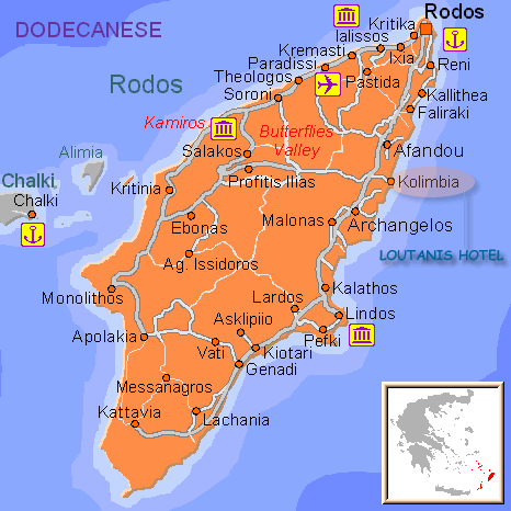
The island of Rhodes is the biggest one in the Dodecanese (Twelve Islands) group which is composed of more than twelve islands but has keep this name since the time when the prefecture was composed of twelve islands; this group is also known as the Southern Sporades. Rhodes is lying on the south-east corner of the Aegean, opposite the coast of Asia Minor. The island has a total area of 1398 square kilometres and is 79, 7 kilometres long and 38 kilometres wide.
The capital of the island is the medieval city of Rhodes which is also the capital of the Dodecanese Prefecture.
The island is divided into then municipalities which are the Municipality of Rhodes (the capital) and the municipalities of Ialysos, Petaloudes, Kamiros, Kalithea, Attavyros, Afandou, Archangelos, Southern Rhodes and Lindos. The population of the island consists on more than 100, 000 inhabitants most of whom live in the capital. The population leaving in the city is about 60,000 inhabitants.
The City of Rhodes has a total area of 25, 884 hectares and its plan covers about 73, 912 hectares and is being extending of 1783 hectares more in order to welcome new districts.
The coastline of the island of Rhodes is indented and embellished with golden sands, multicoloured pebbles and crystalline waters. The western coast is more fertile and forested than the eastern one but also has rocky beaches. The inland of Rhodes is hilly and wooded, offering a lush and flowered landscape.
The coastline of the island of Rhodes is indented and embellished with golden sands, multicoloured pebbles and crystalline waters. The western coast is more fertile and forested than the eastern one but also has rocky beaches. The inland of Rhodes is hilly and wooded, offering a lush and flowered landscape.
© Copyright 2006 HOTEL LOUTANIS All Rights Reserved.